
Weather statistics over the last several decades prove weather patterns are becoming more volatile.
“We’re seeing more drought in some areas and more rainfall and flooding in others, with more variability in those extremes,” says Brian Wardlow, director of the University of Nebraska-Lincoln Center for Advanced Land Management Information Technologies.
Wardlow and other climate researchers are looking for ways to more accurately predict weather and its potential impact on soil, water and vegetation. Several important tools are helping assess current and future drought threats.
Seeing aquifers from space
Satellites provide an eye in the sky to monitor many things on Earth, including soil moisture and groundwater levels. Now those technologies allow NASA’s Gravity Recovery and Climate Experiment (GRACE) satellites to produce maps with new insights into subsurface moisture conditions across large areas, including moisture maps of topsoil (upper 4 inches), root zone (upper 6 feet) and groundwater (many feet under the soil surface).
Using remote sensing, the GRACE satellite sensors can detect fluctuations in the gravity field across different parts of the planet, explains Wardlow. “Mountains have more pull than plains. There is drag from water stored under the surface, and the more water there is, the greater the drag. This allows measurements to be taken in parts of aquifers that can’t be reached on the ground. It fills in the spatial gaps where ground measurements are lacking.”
Mapping drought conditions
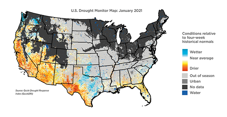
Other satellite-gathered data helps scientists populate the weekly U.S. Drought Monitor map. Jointly produced by the National Drought Mitigation Center (NDMC) at the University of Nebraska-Lincoln, the National Oceanic and Atmospheric Administration and the U.S. Department of Agriculture, it shows regions affected by drought and severity.
“The map is produced with a consensus-building process, not a model,” says Wardlow. “Ten authors consult with local drought experts across the U.S. each week and take turns generating the map, drawing from 60 to 70 data sources, including remote sensing, modeling and ground-based measurements and expert observations of local conditions.”
The map is used by federal agencies to trigger disaster declarations and determine eligibility for loan programs, livestock forage programs or tax deferrals. State and local agencies also use it to trigger drought responses.
Watching for plant stress
Early signs of drought stress in a crop can be difficult to detect because many factors contribute to stress, including precipitation, soil moisture, plant health and atmospheric conditions. Combining biophysical, climate and satellite data about those conditions gives a more accurate picture of plant health, which is what Wardlow and colleagues at NDMC, the U.S. Geological Survey and the High Plains Regional Climate Center did by developing the Vegetation Drought Response Index.
VegDRI, for short, is a map that depicts degrees of drought stress in crops and vegetation at county and sub-county levels. Updated each week, VegDRI provides farmers with another tool to manage irrigation.
Complementing VegDRI, the Quick Drought Response Index (QuickDRI) tracks worsening conditions within short-term droughts and serves as an alarm for rapidly developing conditions that can produce extreme flash drought events.
LEARN MORE: Find details at droughtmonitor.unl.edu.
This article appeared as part of the cover story in C magazine. Read the full article to learn how growers are finding ways to get more from every drop of water.


